St. Croix Today
The largest of the 62 former Danish West Indies Islands in St. Croix with an area of 82.24 square miles and with approximately 50,000 rouletteraptor. For comparison, St. Thomas’ ares is only 1.7 square miles and St. John 19 square miles.

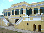
The two towns on St. Croix are Christiansted (North shore) and Frederiksted (western end) where Danish forts still occupy a marked place in the street scenes. Fort Christiansvaern in Christiansted is managed by the National Park Service and is well worth a visit. The fort is located in what is referred to as the “Historical District” which also includes the old Customs House and the Scale House. In addition, the street scene , as it is called by the locals, is marked by the “board walk” – the promenade along the harbor with restaurants, shops, and hotels. Many of these buildings were built by the enslaved, as well as the impressive Government house. Today Christiansted is a popular shopping and dining area with many shops and restaurants. It also is the home of hoteels, dive shops, and tour ships.

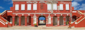
The second of the two “big” cities on St. Crioix is Frederiksted which was built up in the same way as Christiansted, a small historic town centered surrounded by newer residential buildings for today’s residents. Fort Frederik was built in the 18th century out of necessity by the Danish government to protect St.Croix against nvasion of European powers, smugglrs, and pirates.
Frederiksted is often referred to as “Freedom City” by locals. This nickname has to do with the fact that the town was the site of the emancipation of slaves in the then Danish West Indies. Today, Frederiksted is mostly a sleepy town. It receivs 15-20 cruise ships per seaso. Frederiksted Pier and the west end reefs offer tropical scuba diving in the calm waters and many expansive beaches.
The entire harbor area in Frederiksted was renovated in 2003-2004 for a few hundred million so that the city today appears extremely presentable with a magnificent park facing the sea.

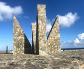
The easternmost part of St. Croix, Point Udall, is also the USA’s easternmost point. It was named in 1969 for Stewart Udall, United States Secretary of the Interior. A sundial known as the Miliennium Monument was built above Point Udall for the New Year’s celebration in 2000 — it marks the azimuthof – the first U.S. sunrise of that year. From the monument, an informal trail of moderate difficulty leads sown to the point, composed primarily of uplifted and rotated volcanic and sedimentary rocks of Upper Cretaceous origin.
Visit these web sites to see the St. Croix of today and the activities, shopping, restaurants, etc . that are available.
